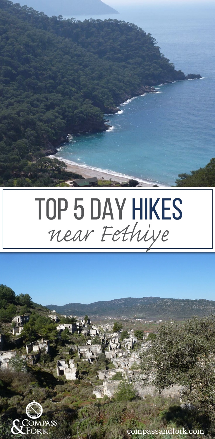
Fethiye is the start of the Lycian Way, a 324 mile or 540 kilometer long distance hiking trail ending near Antalya. There are a number of additional day hikes near Fethiye. Maps are posted at the trail heads, and the trails recommended are way marked. It was difficult to find any additional information here on the ground although we did come across a Fethiye hiking book in a café (published by the local culture authority) but we could not find it anywhere for purchase.
Nevertheless if you can follow the trail markers, you should be okay. In the hikes below all distances are ONE-WAY.
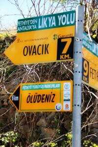
1. From Fethiye to Kayakoy
 There are two paths one is 5.6 miles (9 km) and one is 4.2 miles (7 km). These are part of the regional system and are marked with red and yellow paint marks as trail markers.
The 5.6 mile trail leaves from with the main road leading to Kayakoy (below the rock tombs overlooking Fethiye) or the 4.2 mile trail near the harbor by town. Look for the signs.
It is possible to combine the two and make a loop, or walk one way and take the dolmus (small white vans that provide public transport.) back. You can catch the dolmus in KayaKoy near the old ruins on the hill, Karmylassos. The hike ends/begins here as well.
The trail is rather steep but it is easy walking. Small segments of the trail are along the road, which is quite winding. The 4.2 mile trail from the main harbor starts as a trail then continues along a dirt road. This road is quite busy on the weekend as the locals use this area for family picnics. If you can I would hike it during the week. Also bring water. There is some shade along the trail, but if it is warm, it is better undertaken in the morning or evening.
If you want to walk downhill, start in KayaKoy and walk to Fethiye. You will see the ruins on the far side of the village when you come over the hill from Fethiye.
Lunch can be had in either Fethiye or Kayakoy if you would like a break before walking back.
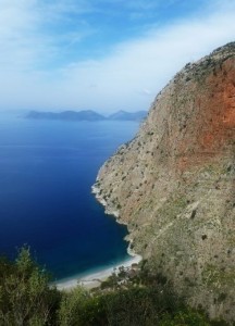
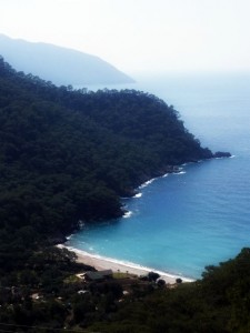
2. Kayakoy to Oludeniz
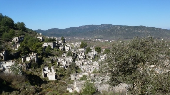
4.2 miles or 6 kilometers one way The trail leaves from near the ruins of the old Greek village of Karmylassos in Kayakoy.
The ruins in KayaKoy are not ancient ones, but are from the 1920’s when the village was abandoned as part of the population exchange with Greece. It was populated by Greeks that were returned to Greece. Turkish people living in Greece were sent back to Turkey as part of the program.
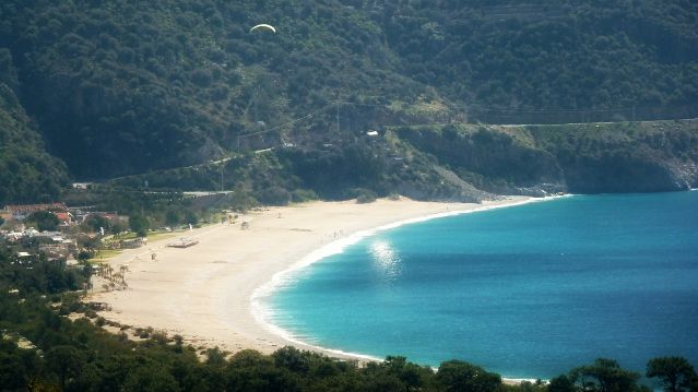
You must purchase a ticket for the ruins if you depart from here (5TL (USD $2) per person). You pass through the ruins, over the pass, and walk down toward Oludeniz. The scenery on this hike is stunning. You can hike one way if you return via taxi or Dolmus. If not it is over and back the same way. You might combine this with lunch in Oludeniz or alternatively start from Oludeniz and lunch in KayaKoy.
Oludeniz is referred to as the “Blue Lagoon” and is often featured on travel advertisements for the Lycian Coast.
3. Faralya to Kirme
At 2.4 miles or 4 km one way, this up and back hike from Faralya is the shortest option. This hike leaves from the Oludeniz end of Faralya, the signs for the hike are on the left as you enter town traveling from Oludeniz.
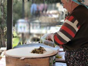 The highlights of this hike are the scenery and the quaint village of Kirme. Kirme is small but it had a café (set up in someone’s yard) providing cold drinks, freshly squeezed juice and the best golzeme (pancake) we had during our trip.
Golzeme, either sweet or savory varieties, are filled with a variety of fillings. This particular one was filled with spinach, village cheese and some herbs and spice. It was simple, but a delicious and welcome break on our hike. Plus we got to watch them make the pancake.
The hike climbs sharply coming out of Faralya and provides great views of the coastline and Faralya. There are a number of accommodation options in Faralya if you would like to stay in this area and day hike.
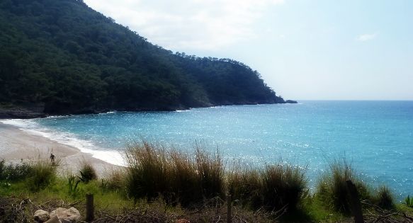
4. Faralya to Kabak via the Coast
6.3 miles or 9 Kilometers
This hike leaves from the Oludeniz end of Faralya. The signs pointing to it are near a small convenience store on the right hand side of the road as you travel away from Oludeniz. The signs are not on the main road and point down a road (paved). The hike to Kirme leaves from the other side of the road.
The first 2-3 kilometers of this hike are quite rugged with a bit of climbing. You start walking down a road for 600 meters or so, then the real hike begins. There is a view from above of Butterfly Valley, which can be reached via boat from Oludeniz. It is a beautiful valley and the photo opportunities here are excellent.
The hike then continues along the coastline for several kilometers. You do pass a couple of small eateries that may or may not be open depending on the time of year. You need to carry water and food supplies for this hike in case there is nothing.
About 7 kilometers into the hike you will pass “welcome to Kabak” painted on some rocks. Don’t be fooled, you are still several kilometers from Kabak. From this marker, the hike climbs sharply, eventually running into a dirt road for a section of the hike, before rejoining a trail to Kabak. Kabak is a small town with a lovely beach, but it is not visible on this hike until you are almost there.
There is a variety of accommodation and eating options in Kabak. We did not stay here but the Tree House Pension looked very nice. Camping is also available. This is a popular stop for hikers on the Lycian Way.
 The climb from the beach to Kabak town has two options, through the accommodation or via a path that leaves from the right end of the beach (facing the water). (This forms a loop from the town down to the beach and back.) The path through the accommodation is the easier option as it is not as steep and has some stairs.
There are several options for return to Faralya, back the way you came, hiking the inland option outlined below, or via the Dolmus to Faralya or Oludeniz.
5. Faralya to Kabak (inland)
4.9 miles or 7 Kilometers This trail heads inland and is part of the Lycian Way (red and white trail markers). While the coastal track is below the road, this path is above the road and offers views of both the coast and the villages below.
The trail is easy to follow and after a brief climb at the beginning, not too strenuous.
If combining with hike number 4 to form a loop, it might be best to walk to Kabak via the Coastline and return via the inland route. Note: this is a long hike of 16 kilometers and would take about 8 hours, with some quite strenuous sections (especially the beginning along the coastline). If you are leaving from Kabak, walk the coastal path first then the inland path back to Kabak.
A few Words about the Lycian Way
It is possible to hike sections of the Lycian Way as day hikes, or to through-hike the entire trail. Additional information can be found on the official Lycian Way section of the Culture Routes Society.
If you plan to hike this, source a book and map BEFORE you arrive in Turkey. We did not locate the book in Fethiye despite numerous attempts to locate one. We found a map, not a great one, at the book kiosk in Fethiye Harbour. There is accommodation along the route or you can camp for free. The Lycian Way section of the Culture Routes Society above provides a listing of accommodation.
Food is available along the way and many villagers cater to people walking the trail so you are welcome to come in for a bite or restock your supplies.
Water is available free in every village from taps, so you can refill as you go. Depending on the source and time of year you may want to purify the water or purchase bottled in some places. Check the FAQs on the official site for more information.
There are a couple of blogs out there about people who have hiked along the Lycian Way, try the folks at Married with Luggage blog or Plod’s Lycian Way both provide a day by day guide. If you are planning to hike the full length, it is worth a look. There are other blogs out there and I recommend you search for them. Sometimes they provide valuable information about accommodation and routes.
During peak times (April/May), if you are not planning to camp, it is recommended you book accommodation in advance. The trail can get quite busy. We hiked a section nearer the Antalya end and it was much busier than where we had been in Fethiye (it was a bit later in the season).
At times the trail markers can be hard to find, especially when you enter into villages. Ask the locals, bring a GPS, and/or get the guidebook.

Gaynor Hynes
Just hiked from Ovacik to Kabak and what a beautiful journey. We set off early to avoid most of the heat and glad we did as the second section Faralya to Kabak was quite a climb.
We took the top route as unsure of the coastal path and were rewarded with some fabulous view
Shobha
Very nice! I never associated hiking with Turkey (more like beaches, hot air balloons in Cappadocia, the limestone formats at Pamakkule and of course Istanbul). Thanks for pointing out the beautiful countryside that lots of tourists never see. Visiting from #wkendtravelinspiration
Editor
Thanks Shobha. The hiking was sublime and you can visit villages a bit off the beaten path. The Lycian coast is certainly a spectacular place.